Showing posts with label lead mining. Show all posts

Wednesday, November 20, 2013

The Industrial Revolution in Reverse - Steam gives way to Water Power


Thursday's Guardian Country Diary describes an unusual piece of industrial archaeology in a remote Northumbrian valley.


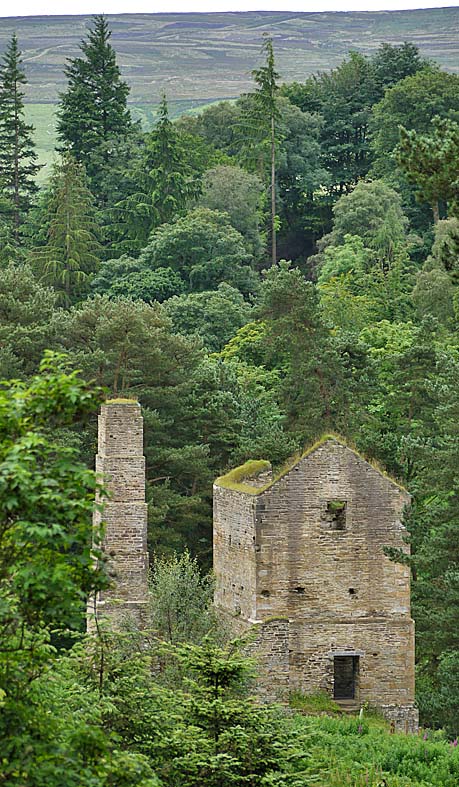
This is the sight that greets you when you follow the track down from the delightfully-named Pennypie cottage towards Blanchland, at the mining hamlet of Shildon (not to be confused with the town of Shildon in County Durham) which is a mile north of Blanchland. All that's left of this community, that in its heyday numbered over 150 people, is a couple of cottages and this old engine house, together with some mine shafts in the hillside.


The engine house was built in 1806 by mine owner John Skottowe, to house a Boulton and Watt steam engine that was built to pump water from the underground lead mine shafts and tunnels. Waterwheel-driven pumps were no longer up to the job so he imported the latest technology from the tin mines of Cornwall.  A contemporary account describes how 'a steam-engine of great power was erected, the cyclinedr being of 64 inches in diameter, and the main beam weighing upwards of nine tons'.

It should have solved Skottows' problems especially as he owned coal mines across the border in County Durham, but the steam engine turned out to be uneconomic and he reverted to waterwheel driven pumps, dismantling the steam engine and transporting it to Backworth colliery. There was no rail access to Blanchland when the mine engine was installed and even when a rail link did arrived (in 1834) the line ended at Parkhead, five miles away.


The likely reason why steam-driven pumping was abandoned is that this little valley is so remote Even today the roads quickly become treacherous after a snow fall and two centuries ago, when they were less well maintained and horses and carts were used, they must often have been impassible in winter. 


After the steam engine was removed the building was converted to miners' accommodation, with the addition of three floors inside, and it became known locally as 'Shildon Castle'. The mine went into decline, unable to compete with imported lead, and many of the miners emigrated - you can read fascinating accounts of some of them by clicking here


This is the slit in the wall where the beam of the steam engine would have rocked up and down. At the top of the slit you can see the fireplaces that were installed when the building was converted to workers' flats.


You can see more photographs of the site, before its recent restoration, by clicking here


There was a vigorous exchange of mine workers and mining technologies between Cornwall and Northumberland in the early 19th. century, which you can read about by clicking here


You can download a useful pdf guide to the geology and landscape around Blanchland by clicking here


You can download a detailed report on Blanchland and its surround area by clicking here


Friday, July 27, 2012

Industrial Archaeology ... and Medical Archaeology too?


Just north of Blanchland in Northumberland there is a road and then a footpath that leads out over moorland towards Slaley, that passes through a little valley where you can find this impressive ruin. It's the engine house that housed the machinery for pumping water out of the lead mines and was built 200 years ago. In its heyday 170 people lived and worked in this valley, extracting minerals underground in work that was back-breaking, debilitating and dangerous. You can read all about the history of this place - and find some fascinating insights into the lives of the people who lived and worked there, by clicking here


The engine house site has recently been cleared of the tangle of vegetation that threatened to engulf it and has been stabilised, so you can have a look at the site. The disturbance has led to the germination of some interesting plants that would have been familiar to the people who once lived and worked here. There are some exceptionally fine specimens of common mullein or Aaron's rod, Verbascum thapsus, that often thrives in disturbed ground. 


The plant produces a few new flowers each day along its long flower spike, so blooming continues for a long time ....


.... and produces a constant supply of pollen for bumblebees over a prolonged period. It's easy to spot these visitors because their pollen baskets are always full of orange pollen.


Mullein is a biennial and produces a beautiful rosette of densely hairy leaves in the first year, that look particularly fine when they are covered with dew on sunny autumn mornings, then in the second year the flower spike elongates. The dense hairs were once shaved from the leaves, dried and used for making lamp wicks and tinder that ignited easily with the slightest spark. A mucilaginous extract of the leaves, boiled in milk, produced a medicine that that was used to treat coughs and it's tempting to think that those who worked in the constantly damp conditions underground here might well have used these plants for that purpose.


Mullein produces vast numbers of seeds but as Sir Edward Salisbury, former Director of Kew Gardens and author of the classic Weeds and Aliens discovered, most fall within about 12 feet of the plant and so it tends to occur in locally dense, self-seeded patches - as it has at this location.


According to C. Pierpoint Johnson in his treatise on The Useful Plants of Great Britain, published in 1863, the tiny seeds "are said to intoxicate fish when thrown into the water, and are used by the poachers for this purpose".


This musk mallow Malva moschata, growing in amongst the mulleins, is also a mucilaginous plant whose extracts were used as an emollient to treat pulmonary complaints.


It's tempting to speculate that this local concentration of plants with medicinal properties is not here by chance, but might have been used by the local miners when they were the amongst the few treatments for their ailments that were available to them. Maybe they are survivors from gardens of houses that have long since vanished .....

Thursday, October 28, 2010

Middlehope Burn, Weardale

Today's Guardian Country Diary traces the route through the old lead mine ruins along Middlehope Burn at Westgate in Weardale. It's hard to believe now but this wooded, steep-sided valley was once a cradle of industry, whose heyday was during the 19th. century. The geology here is composed of alternating beds of limestone, sandstone and shale that erode at different rates and create perfect conditions for the formation of waterfalls like this one next to the cornmill, where the burn cascades over sandstone and greets the visitor on arrival. Rich mineral veins run up through fissures in the strata from the volcanic whin sill below.

The path up the valley is often washed away and has recently been repaired after floods in 2008 and 2009. When there's torrential rain on the fells above, a torrent of water flows down the burn, towards the River Wear. The burn is perfect dipper habitat and the mine ruins upstream provide ideal nest sites.

The first ruins you reach are the Low Slitt Mine bousteads, where partnerships of miners stored their ore before it was crushed between metals rollers. Each compartment belonged to a different partnership. At this point there are mine levels - horizontal tunnels that stretched sometimes for several miles into the hillsides, just large enough to accommodate a pony and its load. There was also a shaft here, at 177 metres deep the deepest in Weardale, where miners were lowered using an Armstrong hydraulic engine. The engine is long gone but its massive mountings lie just around the corner, out of sight in this photograph. Across the burn from the engine lies the old waterwheel pit that also powered machinery. The energy of flowing and stored water provided the power for the whole enterprise.


Further up the valley, where it broadens out into the fells, lies the ruins of Middlehope Shield Mine. Photographs from the beginning of the 20th. century, shortly before the mines closed for good, show gantries of ore crushing machinery here but now all that remains are the jagged ruins of the masonry.

The lead mined here was used for everything from sealing church roofs to producing bullets for some of greatest battles in 19th. century history. Lead, in the form of galena, was separated from the lighter crushed rock on washing floors, using a current of water channeled from reservoirs and from the burn. Now this waterlogged fenny turf is home to plants like the insect-eating butterwort and is a breeding site for frogs and dragonflies. At the head of the valley, at the bottom of the fell in the centre distance, lies yet another mine level that was briefly reopened to mine fluorspar. The whole valley was a cauldron of activity during the industrial revolution but now it's a designated Site of Special Scientific Interest and part of the North Pennines Area of Outstanding Natural Beauty - and a European Geopark. Nature has worked wonders at healing the scars over the last century.

On a mellow autumn afternoon it's hard to imagine the cacophony of noise and the dirt and dust that must have filled the valley. The drier areas are now pasture, providing fine conditions ......

... for a range of grassland fungi, like this little gem with gills like cathedral vaulting... which I think may be a snowy waxcap Hygrocybe virginea (?), which sometimes develops with a funnel-shaped cap.
These, I've yet to identify (anybody know what they are?)... I think they could be dung roundheads Stropharia semiglobata

... and this is meadow coral Clavulinopsis corniculata still in the early stages of growth.

All the power for the mine machinery came from the skillful management of flowing water, channeled from the burn and tributaries, but no one seems absolutely sure where all the channels were. Floods have deposited rock and silt as the burn has changed its course, but here and there underground channels like this one bubble to the surface then disappear into the depths again.

Looking back as you climb up out of the valley you can see traces of the railway that carried the ore away from the site. The ruins of Middlehope Shield Mine lie amongst the trees in the centre middle distance and to the left of those are washing floors and yet another mine level (White's Level) cut into the hillside. The bridge abutments in the foreground carried the mineral railway over the burn.

Climb higher still and you can see the track bed of another railway - the smooth green track running slightly downhill to the right from the centre of this picture, just above a wall. In the distance, rays of sunshine are sweeping across the flanks of Chapel Fell that looms up out of the haze.
At the top of the fell now, and the sun is lighting up West Slitt Dam, the reservoir whose water provided the power for the Armstrong hydraulic engine below, that hauled miners up from their underground tunnels.

There were levels cut to mine lead all the way up the fellside. The green tracks fanning out here are soil tips, where ponies dragged carts of rock waste and dumped it.
At the end of a long shift underground hewing rock, this is the panorama that they would have enjoyed when they trudged wearily back down the hill into Westgate. It was a hard way to earn a living.

If you are interest in this circular walk, you can download an excellent Geotrail here.

Adrian's Images has a photo of the starting point for the walk - the footpath up to the strangely-named Weeds, at the lay-by in the centre of Westgate, here.


Tuesday, August 4, 2009

Still Clinging On: Durham's Red Squirrels


The North of England Lead Mining Museum at Killhope in Upper Weardale (http://www.killhope.org.uk/Pages/KillhopeHomePage.aspx) is a wonderful place to learn more about what must have been one of the toughest ways to earn a living yet devised, hacking lead ore out of the Pennines. The fully restored mine and lead processing equipment, including a giant overshot water wheel, and the exquisite collection of mineral crystals extracted from local mines, are just a few of the delights that the museum has to offer. In the spruce plantation behind the mine you can still watch red squirrels at close quarters, at two feeding stations that have been set up there. They are probably extinct elsewhere in County Durham but a small population still thrives here. During our visit yesterday we watched four red squirrels , including this almost white-tailed example which is typical of our native sub-species – re-introduced populations of European origin tend not to display this distinctive feature. A couple of the squirrels still carried their long ear tufts, which red squirrels are supposed to lose in summer; presumably they hadn’t read the ID guides. If you visit Killhope, which opens at 10am., head straight for the squirrel hides, before the visitors to the mining museum start exploring the woodland trail, and you’ll stand the best chance of seeing these fast-disappearing animals.

Tuesday, April 28, 2009

The Jewel Mines


Throughout the eighteenth and nineteenth century, Weardale was a major centre for lead mining. Lead ore was extracted from narrow veins in the rocks and tens of thousands of tonnes of spoil were hauled out of tunnels by ponies pulling trucks carried on wooden rails. It was tipped at the end of the tracks, creating fan-tails of spoil that can cover whole hillsides, as they do in this photograph taken at Cowshill last weekend. Weather constantly erodes the heaps, revealing beautiful amythyst-coloured crystals of ‘fluorspar’, or fluorite amongst the spoil. When our kids were little they used to bring back pocketfuls of these ‘jewels’ from ‘the jewel mines’. Some of the finest crystals – like those at http://www.ukminingventures.com/WeardaleMines.htm
- are sought after by collectors. Footpaths and bridleways across the dale are decorated with fluorspar fragments that look their best after a light shower of rain, glittering in the sunlight.