Showing posts with label Middlehope burn. Show all posts

Wednesday, May 21, 2014

Wildlife in an old lead mine


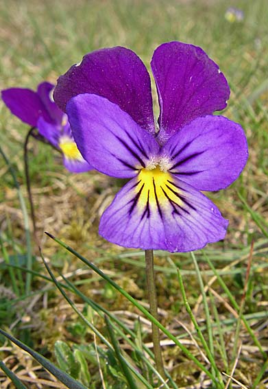
Thursday's Guardian Country Diary describes some of the wildlife that has colonised the old disused lead mines at Westgate in Weardale. Many of the industrial processes that took place here (and ceased early in the 20th. century) involved the use of water, to power a hydraulic engine and to separate lighter stone from heavier lead ore (galena). The legacy is an excellent habitat for wetland wildlife which is now a Site of Special Scientific Interest.


I almost trod on this down-in-the-mouth toad, whose colour blended so well with the mosses around one of the shallow pools where it had spawned. You can see the ridge just behind its eye where the poison glands are located, which deter predators.


In this view you can see most of the main site, with Middlehope burn snaking through the valley. In the foreground you can see bridge parapets for the railway bridge that crossed the burn - ore was taken out on railway trucks pulled by horses. In the middle distance, just to the left of the third bend in the burn, you can see a rectangular depression with a pool of water in the centre. This was once a reservoir.


The reservoir is fed by water flowing out of this mine entrance, known as White's Level. The tunnel is just large enough to accommodate a small pony. Some of these mine levels stretch for miles under the hillside but are now lethal because some lead to vertical shafts where miners were winched down in baskets to tunnels that followed lead veins at lower levels in the strata.

The water flows out through a bed of watercress and into...


.... the silted up reservoir, mentioned earlier. This is a great site for dragonflies in summer, and also a breeding site for toads. The retaining wall on the left, like most of the walls of the mine ruins that were constructed from limestone blocks, is excellent habitat for ferns, like .... 


... the dainty brittle bladder fern.


These are ruins of lead mine buildings downstream, with more waterlogged ground. The key elements for plant growth - soluble nitrogen and phosphorus - are rapidly washed from the soil by rainfall and flowing water, so some of the plants that grow here are adapted to obtaining these minerals by other means.


This is marsh lousewort, a partial parasite on the roots of grasses, that connects with their root systems and siphons off their mineral supplies, and ....


.... these are plants of butterwort. Those rosettes of sickly yellow-green leaves are covered in sticky mucilage glands that trap small insects, which are then digested by enzymes secrete by the leaves.


Downstream Middlehope burn flows through the sheltered, wooded valley known as Slitt woods and ....


...... when it reaches Westgate in Weardale flows over a series of picturesque waterfalls into the river Wear.


Saturday, August 6, 2011

Go with the Flow


Could there be any more relaxing way of whiling away a warm summer's afternoon than to lean over a bridge and watch trout in a stream? With a few sinuous flicks of their tails they expend just enough energy to hold station in the current, waiting for food to be wafted in their direction.
I photographed these beautifully marked brown trout in Middlehope burn, a crystal-clear tributory of the river Wear at Westgate in Weardale.

Saturday, July 2, 2011

Vegetable Vampires 4: Eyebright


Eyebrights Euphrasia spp. are possibly the most attractive of all the hemiparasites, which all link their roots to those of surrounding plants and siphon off their water supply and mineral nutrients. There is a bewildering number of species in this genus - 21 species and over 60 hybrids listed in Clive Stace's New Flora of the British Isles. This little ground-hugging example, which I haven't identified, was growing on lead mine spoil tips at Middlehope Burn in Weardale, and ...

.... this much taller one, part of a dense population of thousands of plants, was growing amongst yellow rattle in one of the high pastures on Chapel Fell in Weardale.

Thursday, June 16, 2011

Vegetable Vampires 2: Lousewort


Lousewort Pedicularis sylvatica is one of several members of the foxglove family (Scrophulariaceae) that have evolved to become hemiparasites, attaching themselves to the roots of surrounding plants and siphoning off their water and dissolved mineral supply.  Lousewort leaves are convoluted and quite small in comparison with the flowers, which sit inside an inflated calyx that later encloses the seed capsule.

I've seen several suggestions concerning the origin of the name 'lousewort' but one plausible explanation is that it sometimes tends to grow in seasonally wet pastures where there's a high incidence of parasites that infest grazing animals. William Withering, the 18th. century physician and botanist, issued stern advice about the dangers of this plant to livestock. Writing in his Botanical Arrangement, published in 1776, he warned "If the healthiest flock of sheep are fed on it, they become scabby and scurfy in a short time; the wool gets loose, and they will be over-run with vermin". 

Marsh lousewort P. palustris, sometimes known as red rattle, grows in much wetter, permanently boggy sites. Common lousewort is a ground-hugging plant but marsh lousewort sometimes grows to 50cm. or more in height. William Withering also had a low opinion of this plant, commenting that "This is an unwelcome guest in meadows, being very disagreeable to cattle".
For more hemiparasites, click here

Tuesday, June 14, 2011

Carnivorous Plants 1: Butterwort

If every there was a Jekyll-and-Hyde of the plant kingdom, this is surely it. At this time of year common butterwort Pinguicula vulgaris produces delightful little violet flowers that attract pollinating insects that ensure that it sets seed, while at the same time catching and digesting small insects on that rosette of sickly yellowish-green leaves down at soil level.

These plants thrive on the permanently boggy conditions on the old lead mine ore-washing floors at Middlehope Burn in Weardale. There's very little nitrogen in the ground but the small insects that they digest make up for that. The surface of the leaf is covered in glistening, stalked glands producing mucilage that glues the insect down, then tiny glands embedded in the leaf surface release diestive enzymes that convert it into nutritious soup. The rolled edges of the leaves keep the pool of digestive enzymes in place. To see the capture and digestive glands of another, more exotic butterwort species in more detail, click here. The glands release protein-digesting enzymes that curdle milk and butterwort leaves were once used in the first steps in making butter - hopefully making sure that there were no flies stuck to the leaf first!

Butterwort keeps its welcoming flowers and deadly digestive equipment well separated via a tall flower stalk...

... and the precious nectar, there to attract small bee pollinators equipped with a suitably long proboscis, lies inside that nectar spur that you can see at the back of the flower - protected by a forest of fine hairs that prevent small, non-pollinating insects from crawling in and stealing it.

Sunday, June 12, 2011

Weardale

Some photographs of Weardale, taken on the walk down from the top of Middlehope Burn into Westgate this morning (they all look better if you double-click on the images to enlange them).

Up on the fellside the hawthorns are still in flower, long after those down in the valley bottom have shed their petals.

The hay meadows in Weardale are just approaching their peak flowering period.

Haymeadows: buttercups (yellow);cow parsley and pignut (white); sorrel (russet-brown)

The high pastures on the far side of the valley - the olive green patches are rushes (Juncus spp.) which thrive in poorly drained pastures. These rather dull plants have the the most beatiful internal structure, which you'll see it you click here.

Monday, April 25, 2011

Spring Wild Flowers in Weardale

Last autumn I posted some pictures of a walk up through Slitt Woods in Weardale, following the course of Middlehope Burn upstream. These pictures were taken this weekend, following the same route, starting with masses of sloe blossom in the woodland, attracting the attention of this green-veined white butterfly.


All through the woodland there's a fine display of primroses and around the hazels ...


.....these flowers of toothwort, which is a parasite on hazel roots, are in bloom.

The mountain pansies are just coming into flower in the grassland on the moorland edge. There are numerous colour variations.


Sedges thrive in the short, sheep-grazed turf. The yellow 'paintbrush' is the male flower, composed of numerous stamens, and the white feathery stigmas of the female flowers can be see further down the stem

The ruins of the old lead mine buildings form a natural rock garden for dog violets


Field woodrush, growing in the short turf.


The early purple orchids at the top of the woodland are earlier than ever this year, thanks to the warm, dry weather.

Marsh marigold thrives around the old lead washing floors, where lead was separated from crushed rock using the force of flowing water. The parabolic flowers of marsh marigold focus the sun's rays and the temperature inside the flower is always a few degrees higher than outside, making them a popular resting place for sun-basking flies.

Up in the edge of the high pastures cowslips are in bloom.

Saturday, April 23, 2011

Oystercatchers and Swallows

One of the characteristic bird sounds out on the moorlands of Weardale at this time of year comes from oystercatchers that arrive here from the coast to breed. When we were out at Middlehope burn yesterday their calls echoed around the hillside ....

... and we watched several of these noisy courtship chases.


The swallows were back too. Every year at least one pair nest just inside the entrance to this mine level (below) - the tunnel that provided access to the lead veins that were once the source of the mineral wealth of this valley.

The mine tunnel entrance is sealed off for safety but the swallows ...
..... hurtle towards the bars, chattering as though they are excited to be back in this bleak moorland landscape after spending the winter in Africa. 

Here's one coming out of the mine entrance, after checking the state of last year's nest inside. They fly towards the gaps between those iron bars with unabated speed and must have to time their wing up- or down-stroke with incredible precision to ensure that they don't break a wing on the iron grill.

Thursday, October 28, 2010

Middlehope Burn, Weardale

Today's Guardian Country Diary traces the route through the old lead mine ruins along Middlehope Burn at Westgate in Weardale. It's hard to believe now but this wooded, steep-sided valley was once a cradle of industry, whose heyday was during the 19th. century. The geology here is composed of alternating beds of limestone, sandstone and shale that erode at different rates and create perfect conditions for the formation of waterfalls like this one next to the cornmill, where the burn cascades over sandstone and greets the visitor on arrival. Rich mineral veins run up through fissures in the strata from the volcanic whin sill below.

The path up the valley is often washed away and has recently been repaired after floods in 2008 and 2009. When there's torrential rain on the fells above, a torrent of water flows down the burn, towards the River Wear. The burn is perfect dipper habitat and the mine ruins upstream provide ideal nest sites.

The first ruins you reach are the Low Slitt Mine bousteads, where partnerships of miners stored their ore before it was crushed between metals rollers. Each compartment belonged to a different partnership. At this point there are mine levels - horizontal tunnels that stretched sometimes for several miles into the hillsides, just large enough to accommodate a pony and its load. There was also a shaft here, at 177 metres deep the deepest in Weardale, where miners were lowered using an Armstrong hydraulic engine. The engine is long gone but its massive mountings lie just around the corner, out of sight in this photograph. Across the burn from the engine lies the old waterwheel pit that also powered machinery. The energy of flowing and stored water provided the power for the whole enterprise.


Further up the valley, where it broadens out into the fells, lies the ruins of Middlehope Shield Mine. Photographs from the beginning of the 20th. century, shortly before the mines closed for good, show gantries of ore crushing machinery here but now all that remains are the jagged ruins of the masonry.

The lead mined here was used for everything from sealing church roofs to producing bullets for some of greatest battles in 19th. century history. Lead, in the form of galena, was separated from the lighter crushed rock on washing floors, using a current of water channeled from reservoirs and from the burn. Now this waterlogged fenny turf is home to plants like the insect-eating butterwort and is a breeding site for frogs and dragonflies. At the head of the valley, at the bottom of the fell in the centre distance, lies yet another mine level that was briefly reopened to mine fluorspar. The whole valley was a cauldron of activity during the industrial revolution but now it's a designated Site of Special Scientific Interest and part of the North Pennines Area of Outstanding Natural Beauty - and a European Geopark. Nature has worked wonders at healing the scars over the last century.

On a mellow autumn afternoon it's hard to imagine the cacophony of noise and the dirt and dust that must have filled the valley. The drier areas are now pasture, providing fine conditions ......

... for a range of grassland fungi, like this little gem with gills like cathedral vaulting... which I think may be a snowy waxcap Hygrocybe virginea (?), which sometimes develops with a funnel-shaped cap.
These, I've yet to identify (anybody know what they are?)... I think they could be dung roundheads Stropharia semiglobata

... and this is meadow coral Clavulinopsis corniculata still in the early stages of growth.

All the power for the mine machinery came from the skillful management of flowing water, channeled from the burn and tributaries, but no one seems absolutely sure where all the channels were. Floods have deposited rock and silt as the burn has changed its course, but here and there underground channels like this one bubble to the surface then disappear into the depths again.

Looking back as you climb up out of the valley you can see traces of the railway that carried the ore away from the site. The ruins of Middlehope Shield Mine lie amongst the trees in the centre middle distance and to the left of those are washing floors and yet another mine level (White's Level) cut into the hillside. The bridge abutments in the foreground carried the mineral railway over the burn.

Climb higher still and you can see the track bed of another railway - the smooth green track running slightly downhill to the right from the centre of this picture, just above a wall. In the distance, rays of sunshine are sweeping across the flanks of Chapel Fell that looms up out of the haze.
At the top of the fell now, and the sun is lighting up West Slitt Dam, the reservoir whose water provided the power for the Armstrong hydraulic engine below, that hauled miners up from their underground tunnels.

There were levels cut to mine lead all the way up the fellside. The green tracks fanning out here are soil tips, where ponies dragged carts of rock waste and dumped it.
At the end of a long shift underground hewing rock, this is the panorama that they would have enjoyed when they trudged wearily back down the hill into Westgate. It was a hard way to earn a living.

If you are interest in this circular walk, you can download an excellent Geotrail here.

Adrian's Images has a photo of the starting point for the walk - the footpath up to the strangely-named Weeds, at the lay-by in the centre of Westgate, here.